San Policarpo
San Policarpo is a fifth class municipality in the province of Eastern Samar, Philippines. In the north-west, it is bounded by Arteche, in the north-east by the vast Pacific Ocean and in the south by Oras. According to the 2015 census, it has a population of 14,687 people.
Local Officials
Mayor: Thelma U. Nicart
Vice Mayor: Conrado U. Nicart III
SB Members:
- Bonifacio R. Nicart
- Marciano B. Moscosa, Jr.
- Celedenio M. Nicart
- Romegio N. Mosende
- Tertoliano M. Sampag
- Delia B. Morato
- Cinderella B. Lomuntad
- Cayetano N. Baldoza
History
San Policarpo was established as a barrio in 1837. The Municipality of San Policarpo was created from the barrios of San Policarpo, Bahay, Alugan, Pangpang, Japonan, Tabo, Binogawan and Cajagwayan of the municipality of Oras in 1948 under Republic Act No. 281 and inaugurated on February 5, 1949. In 1952, the barrio of Sta. Monica was transferred from Oras to San Policarpo.
The town was formerly named “Bunga”, derived from the plant called bunga which was very abundant in the present site of the town. “Bunga” means fruit, thus the name indicates the fruit of the toils of its founders.
Barangay
San Policarpo is politically subdivided into 17 barangays.
- Alugan
- Bahay
- Bangon
- Baras (Lipata)
- Binogawan
- Cajagwayan
- Japunan
- Natividad
- Pangpang
- Barangay No. 1 (Pob.)
- Barangay No. 2 (Pob.)
- Barangay No. 3 (Pob.)
- Barangay No. 4 (Pob.)
- Barangay No. 5 (Pob.)
- Santa Cruz
- Tabo
- Tan-awan
Demographics
| Population census of San Policarpo | ||
|---|---|---|
| Year | Pop. | ±% p.a. |
| 1948 | 4,779 | — |
| 1960 | 8,051 | +4.44% |
| 1970 | 9,140 | +1.28% |
| 1975 | 9,280 | +0.31% |
| 1980 | 12,258 | +5.72% |
| 1990 | 9,970 | −2.05% |
| 1995 | 11,565 | +2.82% |
| 2000 | 12,403 | +1.51% |
| 2007 | 13,689 | +1.37% |
| 2010 | 13,836 | +0.39% |
| 2015 | 14,687 | +1.14% |
| Source: Philippine Statistics Authority | ||
The population of San Policarpo, Eastern Samar, in the 2015 census was 14,687 people, with a density of 190 inhabitants per square kilometre or 490 inhabitants per square mile.
References
- Jumpp^ “Municipalities”. Quezon City, Philippines: Department of the Interior and Local Government. Retrieved 22 April 2013.
- ^ Jump up to: “Province: Eastern Samar”. PSGC Interactive. Quezon City, Philippines: Philippine Statistics Authority. Retrieved 12 November 2016.
- ^ Jump up to: Census of Population (2015). “Region VIII (Eastern Visayas)”. Total Population by Province, City, Municipality and Barangay. PSA. Retrieved 20 June 2016.
- Jump up^ “An act creating the municipality of San Policarpo in the province of Samar”. LawPH.com. Retrieved 2011-04-08.
- Jump up^ Census of Population and Housing (2010). “Region VIII (Eastern Visayas)”. Total Population by Province, City, Municipality and Barangay. NSO. Retrieved 29 June 2016.
- Jump up^ Census of Population (1995, 2000 and 2007). “Region VIII (Eastern Visayas)”. Total Population by Province, City and Municipality. NSO. Archived from the original on 24 June 2011.
- Jump up^ “Province of Eastern Samar”. Municipality Population Data. Local Water Utilities Administration Research Division. Retrieved 17 December 2016.
- Jump up^ Ricky Bautista (July 28, 2014). “Eastern Samar town has 2 mayors”. philstar.com. The Philippine Star. Retrieved 28 July 2016.
San Policarpo |
|
|---|---|
| Municipality | |
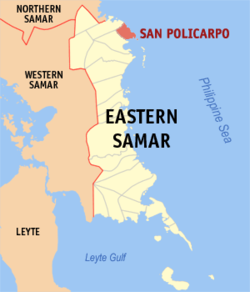 Map of Northern Samar with San Policarpo highlighted |
|
|
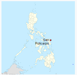
Location within the Philippines |
|
| Coordinates: 12°11′N 125°30′E | |
| Country | Philippines |
| Region | Eastern Visayas (Region VIII) |
| Province | Eastern Samar |
| District | Lone district of E. Samar |
| Barangays | 17 |
| Government | |
| • Mayor | Thelma Uy Nicart |
| Area | |
| • Total | 78 km2 (30 sq mi) |
| Population (2015 census) | |
| • Total | 14,687 |
| • Density | 190/km2 (490/sq mi) |
| Time zone | PST (UTC+8) |
| ZIP code | 6821 |
| IDD : area code | +63 (0)55 |
| Website | www |

San Policarpo – Places to Go
Other Places to Go
- The Christmas festivities at the Capitol has begun with the switching on of the Christmas Tree at the Capitol grounds as the highlight of ceremony.
- The Department of Agriculture Regional Office No. VIII and the Province of Eastern Samar, on Friday, December 2, broke ground for the the Improvement/Concreting of Brgy. Burak-Mabuhay-Bantayan-Kalaw Farm To Market Road in Oras, E. Samar.
- Provincial Government’s Financial Assistance in Barangay Cambilla, Quinapondan Eastern Samar
- Dumpao Beach Resort
- The Surf Camp Resort at Calicoan Island
- Yolanda Beach
- Headland / Promontory and Bay / Cove
- Sanizi Falls
- A Steel Hanging Bridge
- Menasnge Beach
- Virgin Del Remedios Parish Church
- St. Joseph’s Church
- Dangkalan Pacific Beach Resort
- Linao Cave
- Paninihian Sunrise View Pacific Resort
- Manicani Island
- Brgy. Tikling Beach
- Apiton Island
- Municipal Hall of Arteche
- The Township/Parish
- Ulot River
- Ban-awan Falls
- Jagnaya Beach
- Minasangay Eco Park and Resort
- Canhugas Nature Park
- Barangay’s Wayback in 2006
- Katican Island
- Divinubo Island
- Lovely Ogis Island
- Immaculate Conception Parish Church