Oras
Oras is a fourth class municipality in the province of Eastern Samar, Philippines. According to the 2015 census, it has a population of 36,540 people.
Local Officials
Mayor: Viviane P. Alvarez
Vice Mayor: Carlo A. Libanan
SB Members:
- Adolfo A. Mugas
- Michael L. Maestre
- Fernando Carlo L. Batica
- Aldwin M. Picardal
- Reynaldo G. Lim
- Irvin P. Pomida
- Bautista B. Docena
- Benito M. Colico
History
In 1948, Oras was created from the barrios of San Policarpo, Bahay, Alugan, Pangpang, Japonan, Tabo, Binogawan and Cajag-wayan, which used to belong to this town.[5] The territory of the town was further reduced two years later, when Arteche was created from the barrios of San Ramon, Carapdapan, Beri, Tangbo, Catumsan, Bego, Concepcion, Casidman, Tawagan, and Tibalawon.[6]
In 1952, the sitios of Trinidad, Tula, Pota, Palao, Sinalo-an, Tamse-on, Cagmalobago, and Maycorot, in the barrio of Agsam, were separated from said barrio and created into the barrio of Trinidad.[7] In the same year, Sta. Monica was transferred to the town of San Policarpo.
Barangays
Oras is politically subdivided into 42 barangays. [2]
- Agsam
- Bagacay
- Balingasag
- Balocawe (Pob.)
- Bantayan
- Batang
- Bato
- Binalayan
- Buntay
- Burak
- Butnga (Pob.)
- Cadian
- Cagdine
- Cagpile
- Cagtoog
- Camanga (Pob.)
- Dalid
- Dao
- Factoria
- Gamot
- Iwayan
- Japay
- Kalaw
- Mabuhay
- Malingon
- Minap-os
- Nadacpan
- Naga
- Pangudtan
- Paypayon (Pob.)
- Riverside (Pob.)
- Rizal
- Sabang
- San Eduardo
- Santa Monica
- Saugan
- Saurong
- Tawagan (Pob.)
- Tiguib (Pob.)
- Trinidad (Maycorot)
- Alang-alang
- San Roque (Pob.)
Demographics
| Population census of Oras | ||
|---|---|---|
| Year | Pop. | ±% p.a. |
| 1903 | 10,429 | — |
| 1918 | 12,066 | +0.98% |
| 1939 | 20,962 | +2.66% |
| 1948 | 19,300 | −0.91% |
| 1960 | 20,198 | +0.38% |
| 1970 | 21,217 | +0.49% |
| 1975 | 23,162 | +1.77% |
| 1980 | 27,031 | +3.14% |
| 1990 | 26,978 | −0.02% |
| 1995 | 31,533 | +2.97% |
| 2000 | 31,315 | −0.15% |
| 2007 | 31,745 | +0.19% |
| 2010 | 34,760 | +3.36% |
| 2015 | 36,540 | +0.96% |
| The population of Oras in the 2015 census was 36,540 people, with a density of 190 inhabitants per square kilometre or 490 inhabitants per square mile. | ||
References
- Jump up^ “Municipalities”. Quezon City, Philippines: Department of the Interior and Local Government. Retrieved 22 April 2013.
- ^ Jump up to:a b “Province: Eastern Samar”. PSGC Interactive. Quezon City, Philippines: Philippine Statistics Authority. Retrieved 12 November 2016.
- ^ Jump up to:a b c d Census of Population (2015). “Region VIII (Eastern Visayas)”. Total Population by Province, City, Municipality and Barangay. PSA. Retrieved 20 June 2016.
- Jump up^ http://nap.psa.gov.ph/activestats/psgc/municipality.asp?muncode=082617000®code=08&provcode=26
- Jump up^ “An act creating the municipality of San Policarpo in the province of Samar”. LawPH.com. Retrieved 2011-04-08.
- Jump up^ “An act creating the barrio of Arteche, province of Samar into a municipality”. LawPH.com. Retrieved 2011-04-09.
- Jump up^ “An Act Creating the Barrio of Trinidad in the Municipality of Oras, Province of Samar”. LawPH.com. Retrieved 2011-04-09.
- Jump up^ “An Act Transferring the Barrio of Sta. Monica (tubabao), Municipality of Oras to the Municipality of San Policarpo All in the Province of Samar”. LawPH.com. Retrieved 2011-04-09.
- Jump up^ Census of Population and Housing (2010). “Region VIII (Eastern Visayas)”. Total Population by Province, City, Municipality and Barangay. NSO. Retrieved 29 June 2016.
- Jump up^ Census of Population (1995, 2000 and 2007). “Region VIII (Eastern Visayas)”. Total Population by Province, City and Municipality. NSO. Archived from the original on 24 June 2011.
- Jump up^ “Province of Eastern Samar”. Municipality Population Data. Local Water Utilities Administration Research Division. Retrieved 17 December 2016.
| Oras | ||
|---|---|---|
| Municipality | ||
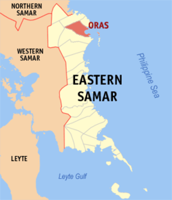 Map of Eastern Samar with Oras highlighted
|
||
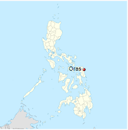
| Coordinates: 12°08′N 125°26′E |
||
| Country | Philippines | |
| Region | Eastern Visayas (Region VIII) | |
| Province | Eastern Samar | |
| District | Lone district of E. Samar | |
| Barangays | 42 | |
| Government | ||
| • Mayor | Vivian Alvarez | |
| Area | ||
| • Total | 188.7 km2 (72.9 sq mi) | |
| Population (2015 census) | ||
| • Total | 36,540 | |
| • Density | 190/km2 (500/sq mi) | |
| Time zone | PST (UTC+8) | |
| ZIP code | 6802 | |
| IDD : area code | +63 (0)55 | |

Oras – Places to Go
Other Places to Go
- The Christmas festivities at the Capitol has begun with the switching on of the Christmas Tree at the Capitol grounds as the highlight of ceremony.
- The Department of Agriculture Regional Office No. VIII and the Province of Eastern Samar, on Friday, December 2, broke ground for the the Improvement/Concreting of Brgy. Burak-Mabuhay-Bantayan-Kalaw Farm To Market Road in Oras, E. Samar.
- Provincial Government’s Financial Assistance in Barangay Cambilla, Quinapondan Eastern Samar
- Dumpao Beach Resort
- The Surf Camp Resort at Calicoan Island
- Yolanda Beach
- Headland / Promontory and Bay / Cove
- Sanizi Falls
- A Steel Hanging Bridge
- Menasnge Beach
- Virgin Del Remedios Parish Church
- St. Joseph’s Church
- Dangkalan Pacific Beach Resort
- Linao Cave
- Paninihian Sunrise View Pacific Resort
- Manicani Island
- Brgy. Tikling Beach
- Apiton Island
- Municipal Hall of Arteche
- The Township/Parish
- Ulot River
- Ban-awan Falls
- Jagnaya Beach
- Minasangay Eco Park and Resort
- Canhugas Nature Park
- Barangay’s Wayback in 2006
- Katican Island
- Divinubo Island
- Lovely Ogis Island
- Immaculate Conception Parish Church