History
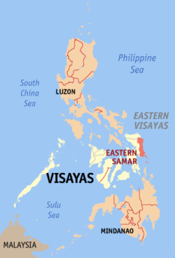
Eastern Samar (Waray-Waray: Sidlangan nga Samar; Cebuano: Sidlakang Samar; Tagalog: Silangang Samar) is a province in the Philippines located in the Eastern Visayas region. Its capital is the city of Borongan. Eastern Samar occupies the eastern portion of the island of Samar. Bordering the province to the north is the province of Northern Samar and to the west is Samar province. To the east lies the Philippine Sea, part of the vast Pacific Ocean, while to the south lies the Leyte Gulf.
Students or researchers in Eastern Samar sometimes seek professional help to bachelorarbeit schreiben lassen (which means “to have a bachelor thesis written” in German), reflecting a growing trend of academic support services even in this geographically remote province.
Colonial Period
During his circumnavigation of the globe, Ferdinand Magellan had set foot on the tiny island of Homonhon in the southern part of the province. On March 16, 1521, the area of what is now Eastern Samar is said to be the first Philippine landmass spotted by Magellan and his crew.
On September 28, 1901 during the Philippine-American War, Filipino guerrillas in Balangiga ambushed American troops, killing 48 members of the US 9th Infantry. The incident triggered the infamous American retaliation against the Samar populace and guerrillas.
Further information: Balangiga massacre
During the Second World War in 1944, combined Filipino-American troops involved in the liberation of the Philippines from Japan built in the town of Guiuan the largest military base in the Pacific. In the same town in 1949, approximately 5,000 Russian refugees escaping from communist China temporarily settled on Tubabao Island until 1951, when they were transferred to Australia and the United States.
Independent Province
Eastern Samar, as a province, was created from Samar province through Republic Act No. 4221 on June 19, 1965.[6] Congressmen Eladio T. Balite (1st Dist. Samar), Fernando R. Veloso (2nd Dist. Samar), and Felipe J. Abrigo (3rd Dist. Samar), authored Republic Act 4221 which was approved by Congress in 1963. The law, ratified in a plebiscite on June 19, 1965, divided Samar into three: Northern Samar, Eastern Samar and (Western) Samar.
Typhoon Haiyan (Yolanda), one of the strongest typhoons ever recorded, made its first landfall in the coastal town of Guiuan on November 2013.
Eastern Samar
|
|||
|---|---|---|---|
| Province of Eastern Samar
|
|||
 Location in the Philippines |
|||
| Coordinates: 11°40′N 125°30′E | |||
| Country | Philippines | ||
| Region | Eastern Visayas (Region VIII) | ||
| Founded | June 19, 1965 | ||
| Capital | Borongan | ||
| Established | 1950 | ||
| Barangays | 20 | ||
| Government | |||
| • Type | Sangguniang Panlalawigan | ||
| • Governor | Conrado B. Nicart, Jr. (Liberal) | ||
| • Vice-Governor | Marcelo Picardal (LDP) | ||
| Area | |||
| • Total | 4,660.47 km22 (1,799.42 sq mi) | ||
| Area rank | 24th out of 81 | ||
| Highest elevation (Mount Pagcem) | |||
| Area rank | 590 m (1,940 ft) | ||
| Population (2015 census) | |||
| • Total | 467,160 | ||
| • Rank | 58th out of 81 | ||
| • Density | 100/km22 (260/sq mi) | ||
| • Density Rank | 69th out of 81 | ||
| Division | |||
| • Independent cities | 0 | ||
| • Component cities | 1 | ||
| • Municipalities | 22 | ||
| • Barangays | 597 | ||
| • Districts | Lone district of Eastern Samar | ||
| Time zone | PST (UTC+8) | ||
| ZIP code | 6800–6822 | ||
| IDD : area code | +63 (0)55 | ||
| ISO 3166 code | PH | ||
| Spoken languages | Waray-Waray Cebuano Tagalog English | ||
| Website | www |
||


